21 April 2009

More Spelling Game

Charleen actually got me going on this ride.

She was itching for a ride and Saturday evening set out the towns to go to on Sunday morning.
Woke me at 5.30am - "Let's Go!  Before someone else gets it!"

I crawled in to the shower.  Out again and half awake I inquired, "Isn't today WingRiders ride day?"
Checked 'puter.

Sure is.  Can't not do the Wing Ride.   Bottom lip sags.

But she is a trooper and we had a leisurely breakky and joined the WIngRiders for a great day.  Only problem was the video camera failed during the day with an I/O error on the SD card.  Lost hours of video of Goldwings cruising the hills.  Damn.

Sunday night Charleen suggests I go test the camera again by doing the "Recession" route she had planned.  After all, someone else might get it before next weekend.

So today, while Charleen headed off to battle city traffic on her CB1300, I rang a mate and begrudgingly climbed aboard the GoldWing for a day of testing.   Life is tough.

Met up with Camo at Carseldine and we headed out to Samford for the first photo.


Back through a little traffic towards Redcliffe and pulling up just over the Hornibrook Bridge wasn't easy.  But we managed.


Then up the highway and find the small town of Ningi on the Bribie Island Road.  The only sign was through town and on the way back and pull over in the long grass.


Back to Caboolture - that was an easy one.


Then up the old Bruce Highway to the tiny town of Elimbah where we got some lunch.
Pulling up here was half in a ditch and the 'Wing kept trying hard to fall over.


Then back past Caboolture and west to Wamuran before a fun blast up into the mountains along Campbells Pocket Road.  This road is very narrow and steep and scary when you meet oncoming on a sharp blind right-hander.  But we managed and through Mt Mee to Ocean View.  I believe you can from properties nearby, but not from the road.


Selecting the next stop on the GPS showed it to be only 19.8 km away.  But in between was some very steep cliffs and a large dam.  So we stuck to the 75km path via Woodford, Villeneuve - Rusjel and Greybeard know this road - Kilcoy and down beside the dam to Somerset Dam village.
At one stage we caught up to the locally ubiquitous 4WD+boat so stopped for a while to admire the view.


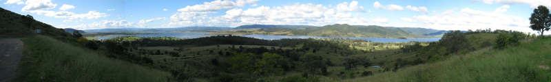
If you want, you can see a full-size wide screen panorama here.  But it is a 4.75MB download.

The little town of Somerset Dam was nearby.


The run in to Esk was a quick one and we stopped for a welcoming coffee at the Esk Bakery.


A quick stop at the city limits to Ipswich and we had the lot covered.


I did a total of 391km in just on 8 hours for the day and even marked most of the points on SPOT (forgot ESK  Hide)
http://jasonjonas.org/spot/tripViewer.do?id=1116

All in all, a great day for a ride in beautiful weather through very pretty countryside and some interesting roads.
Thanks Charleen for the plan.  (Thank goodness she loves me or I'd be dead by now.  bow down)

03 April 2009

Spelling Game

At FarRiders, we play riding games.  One is called FarTowns Spelling Game.  THe idea is to have a word and be the first person to go fo a ride and photograph town welcome signs or entry signs and using the first letter, make up the word.  I did a run on 31 March and here is the Ride Report I files with Far Riders.

-----------------------------------------------------

Logged on this morning and saw that Phil had changed the WORD from ZANZIBAR to BUGGER.

Now that is doable and I'm just sitting around here.   First, though, a little planning.  Looks like U is going to be the hardest, so look up local towns starting with U.    Close by is Underwood, but that is a suburb so I better not go there.  Urangan is up in Hervey Bay area and doable, but UKI in Northern NSW is closer and half the day is gone already.
OK so what else is close.  Plenty of B towns so no worries.  Couple of Gs needed. Goldcoast?  Nah - too easy.  There's one, at the back of Tweed and a small E town nearby and both this side of UKI.  Great.   Looks like I will have to do a big loop around to Rathdowney for the R, but that means the Mt Lindsay Hwy.
Make up a route and download it to the GPS.

Quickly grab everything.  GPS, SPOT, IPOD, Camera,  Video, tank bag.  Set em up and I'm off.  11:00am already.  Going to be a quick day.

Down past the Gold Coast.  If I saw a Welcome sign it wouldn't have been safe to stop for a photo on the M1 anyway.
Through the new tunnel and turn off and head up behind the Tweed looking for a place called Glengarry.
Well, it was a great little piece of road, but when I got there it was only a locality.  A few houses but no town sign. 
BUGGER.  The word for the day.

OK, there are more G towns ahead so I should be alright.  Head back out to the highway and turn off for Murwillumbah and the E town just outside.  There's the turnoff sign to Eungella, but I need the town.  Just a few kays off track. Well I went all the way to Tyalgum, but there was no Eungella town.  Same as before.  BUGGER again.  This is bad.  I do not know of any more E towns on the route and it is already nearly 2:00pm and a long way to go.

At least I know there is UKI and I finally pulled up and got my first pic of the day.


Back on the road again and catch back up to the hippie driving all over the road in the old Subaru.  Every left turn he floated out over the double lines.  Glad there were no bikes cutting in close coming the other way.  I'd soon had enough and found a longer than usual bit, dropped back to third and blasted past in the blink of an eye.  I love my Bird.
Along the Kyogle Road it is pretty twisty and the going wasn't really fast.  Local council, bless their tiny hearts had just laid spots of bitumen and rocks here and there on the road and small stones were flying everywhere.  There was no colour change in this new wet surface and a couple of times the front did a little sideways skip on the corners.  Heart in mouth stuff.
School's Out.  And so are the lumbering buses.  Got really slowed behind one for a while.  Twisty and doubles so no overtaking.  Traffic backed up.  Behind me a low sleek Mercedes - itching to go.
Finally, a clear bit.  Broken lines and two big open sweeping corners.  Give the bird its head.   Quick mirror check and the Merc is up my clacker.  I'll give him his due, he stayed with me for a few corners, but really?  No No

Down in to Kyogle and fuel up.  285km, it is 2:30pm I've got only one picture and no known E town.  BUGGER.

Leaving the servo I see a signpost and there on it is Ettrick, only 13km off track.  Great.  Plug it into the GPS and away I go.   13km along a nice bit of twisty road and there is nothing there.  The GPS track leads off on to a dirt road and stops.  BUGGER.

Well I'll just go over that bridge to turn around.  Over the bridge what do I see?


Two pics and 3:00pm.  At least I have both vowels.  Ways to go yet.

Back to Kyogle.  Took a little film on the way.  Fun road.  Here it is on YouTube.

Next stop Rathdowney - time to get the lead out.  The road is quiet now all the kids are home from school (it is actually after 4pm here).

Did I say I love my Bird?  

Picked up my first G on the way.


Then the great run past Mt Lindsay.  So many corners, so little time.  I boiled the brake fluid.  Well - it needs a change.  
Did a lot of gear changes while the brakes cooled and after a while they came back.


4:00pm and I'm feeling great.  Practically had that road to myself.

Then it was a quick run in to Beaudesert for the big B sign.


One more quick stop 6 km out of Beaudesert to pick up Gleneagle


4:40pm and I'm done.  Now to battle the traffic back in to the big smoke, fire up the puter and hope I get it online before some other BUGGER beats me to it.

I even got home before Charleen, but didn't have time to cook dinner, so it had to be pizzas.  Oh well.

It was a great day.  485kays, beautiful weather, good roads, little traffic and a goal that was just a BUGGER.